
There are many competing demands on our land, from food production, development land for new housing, recreation and nature conservation. All have carbon implications- some positive and some negative. Our ability to achieve our net zero carbon ambition relies on reducing emissions as much as possible combined with natural processes. For land use this means we must:
Composting not only saves money and is great for the garden but provides habitat for wildlife.
Land and land use underpin people’s perception of identity, economic activity, and the vibrancy, vitality, and health of our ecosystems. How we plan for future land use will have significant carbon implications and links to other chapters; if we develop communities which have shops and facilities near where people live and work, we will reduce travel distances and therefore travel emissions.
The food that we eat and where it comes from will have implications; a plant-based diet has a lower carbon footprint and locally produced food has lower associated ‘food miles’.
What happened to the house sparrows? My hedge and feeder were full of them every year for as long as I remember… now there are none.
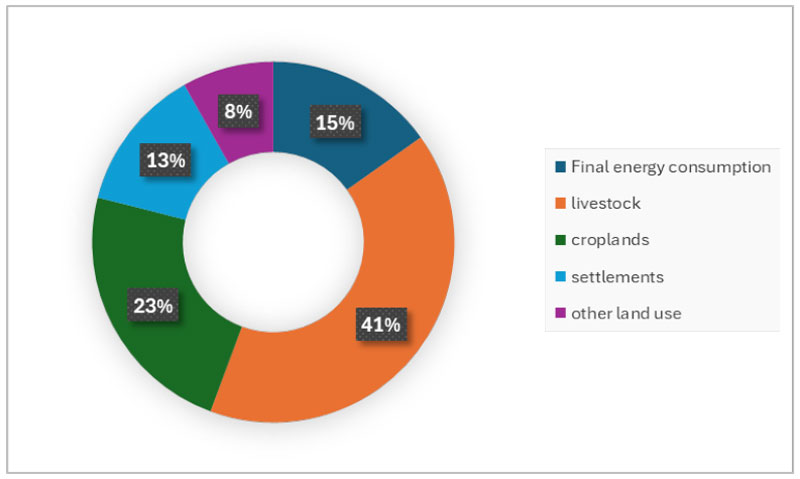
Agricultural processes produce greenhouse gases include methane (from the digestion of food by livestock) and nitrous oxide (from manure and fertiliser) rather than carbon dioxide. Carbon dioxide is sequestered (captured and stored) by the growth of plants which locks away this carbon and prevents it from contributing to global warming.
Climate change is causing diseases that affect woodland stock resulting in accelerated harvesting activities due to diseases like ash dieback and phytophthora. This has resulted in the removal of a significant number of mature and semi-mature trees reducing the County Borough’s overall carbon sequestration potential. Our Action plan will supply detail of how many more trees need planted, or peat protected etc etc in order to help meet net zero.
I quit eating meat after seeing that the beef I purchased came from Argentina!
Drier summers can dry out peat in upland environments and reduce the size of lakes and water levels in rivers and other habitats reducing their ability to store carbon. Peatland restoration is an important aspect of sequestering carbon and contributing to biodiversity. Understanding the state of peatland (and all habitats) and restoring degraded areas is key.
Balancing the competing demands on the way we use our land and what it produces is a vital element of us achieving our net zero ambition as well as contributing to wider health, social, economic and environmental well-being. Sustainable management of natural resources to ensure future generations can grow food effectively will be a major challenge for policy makers between now and 2050.
Caerphilly County Borough is a little over 30km long and 17.5km wide and covers an area of 27,737 Ha, of which 17.85% lies within settlement boundaries. Three quarters of the County Borough is used for agriculture and forestry.
The County Borough has a rich , including areas protected by a variety of statutory (local, national and international) designations and non-statutory designations including 13 nationally important Sites of Special Scientific Interest. Despite these protective measures, the biodiversity of the County Borough is declining, reflecting losses being experienced in other parts of the UK and across the world. Pollinators have been noticeably declining since the 1990s and significantly so in recent years, nutrients in soil need careful management and access to water for agriculture in parts of the UK (including Wales) will be severely challenged by climate change.
The County Borough has a community of around 200 small upland hill farms, primarily engaged in beef and lamb rearing. Farming, particularly livestock farming, can have negative emission impacts. agricultural emissions from livestock have increased over 1990 levels. Across Caerphilly County Borough this increase is primarily driven by livestock rearing. We lack opportunities for the , which reduce on-farm emissions through large livestock units but because they are smaller, these farms adhere to lower stock sizes, likely leading to higher welfare standards and the potential for wider environmental benefits. Research suggests that well-reared upland grass-fed beef has lower emissions.
Within land use, other emissions contribute to climate change and affect broader natural cycles. can degrade water quality, impacting the effectiveness of natural cycles for carbon drawdown.
Instead of allowing building on green spaces, use brownfield sites from empty industrial sites and empty shops to be converted into social housing, with built in energy efficient green energy solutions.
Farm viability remains an issue, creating opportunities for diversification. We have seen an increasing trend in grants for land use on farms being repurposed for activities like dog walking fields and tourism provision.
This shift impacts land use change from agriculture to value-added tourism or other sectors, potentially increasing emissions due to visitor activities. It is unclear if this increase is quantifiable at present. There have been no substantial land use change requests that suggest a significant rise in emissions.
Environmental charity Groundwork Wales at its horticultural site in Caerphilly, runs it’s Routes2Life (R2L) program, providing beneficiaries of all ages with the opportunity to learn and develop a range of practical and horticultural countryside skills, including hedging, strimming, fencing, gardening, pruning and growing fruit and vegetables.
Many post-industrial communities of Wales suffer from the worst effects of poverty and disadvantage. R2L does what its name encapsulates – provides disadvantaged and often vulnerable adults and young people with an education and skills development programme as a positive way forward.
Participants build social skills, confidence and self-esteem, gain Agored Cymru accredited training and enhance CVs with positive experiences working in the outdoors. Part funded by Caerphilly County Borough Council, R2L also engages with local schools to learn from the land, supporting delivery of the curriculum and promoting greener ways of living.
Learning and volunteering on this land-based program supports people who live in the borough of Caerphilly, from a wide variety of backgrounds to connect with others and the landscape, as well as providing them with fresh produce to take home.
The program is supported by Caerphilly County Borough Council and a range of charitable funders and exemplifies the themes of collaboration and informed residents outlined in this chapter, as well as the cross-cutting themes of enabling and education.
From a policy perspective there are many drivers for increasing farming efficiency and diversifying crops. These policies are generally aimed at reducing emissions and energy use. The most significant land use changes locally involve private landholdings which we can influence through the planning process and through our individual and collective purchasing decisions. The 2RLDP will be guided by the LAEP and its identification of areas that have the potential for renewable energy development. This includes pre-assessed areas for wind turbines and allocated areas for solar farms. With the change in technology there is the potential to utilise , where the use of solar panels and agriculture work side by side without the loss of large areas of productive land. Our landscapes have significant potential for renewable energy generation, in particular solar and wind.
For agriculture in particular, the Agricultural Wales Act is key, replacing the previous agricultural bill, which provided basic payments from the EU via the Welsh Government for agricultural practises. These payments have now flowed through to the Act, setting policy for payments to farmers and how they manage their land.
I would love to buy my eggs and seasonal vegetables from my local allotment. Fresh and locally grown, makes sense.
There is now a greater emphasis on nature-based measures within farming and food production. The Sustainable Farming Scheme, which stems from the Agricultural Wales Act, outlines how farmers receive payments for nature-based solutions and nature-based farming on their farms.
The planning framework around land use and land use change is also influenced by this Act. On a local level, 2RLDP includes a green infrastructure (GI) assessment. It maps our land use, habitat protection, and opportunities for tree planting or . The requirement for GI assessments is supported by Welsh Government policy structures including PPW12. The 2RLDP has clear policies that will ensure that the retention of GI is supported and enhanced throughout the Borough.
The Forestry Act and the carbon code for forest recreation, along with national policy directives like the National Forest, guide our woodland creation targets. The replacement Local Development Plan is in pipeline, which will include the green infrastructure assessment. Caerphilly County Borough Council collaborates with the Forward Planning team and the Local Development Plan team to integrate our green infrastructure strategy, which includes land use change and carbon management.
NRW Managed Woodland in Caerphilly and South-East Rivers project
Welsh Government Woodland Estate (WGWE) managed by NRW (examples in CCBC include Cwm Carn Forest) has a role to play in helping society and natural resources to adapt to and mitigate climate change. Plans to improve its structural and tree species diversity will make the woodland and its ecosystem services more resilient to the effects climatic change. After evaluating its net carbon status, our increased understanding helps inform management decisions to protect existing carbon stocks and enhance sequestration, for example by restoring and expanding key peatland and woodland habitats. This will accelerate decarbonisation in Wales and enhance the resilience of natural habitats.
The South-East Rivers project is an NRW-led river restoration project that aims to deliver integrated catchment management across three rivers in the South-East Valleys. Working together with CCBC and other partners, the project will help to protect, enhance and restore natural processes through improving floodplain connectivity, creating and restoring habitats along each river corridor, and working with farmers and landowners to help improve water quality and making CCB healthier. This complements NRW’s ongoing fisheries work programme delivering fish passage and habitat improvement along these rivers.
Green Space Access: We will promote and keep access to green space.
Protect Green/Blue Areas: Protection and maintenance of parks, forests, rivers, and lakes. All land should be protected from contamination and monitored to ensure compliance.
Increase Biodiversity: Encourage biodiversity net gain – using local plants and animals.
Capture Carbon: Landowners will be encouraged to maximise natural ways to capture carbon.
Community Management: Community management of woodlands and green spaces.
Efficient Land Use: Knowledge and understanding of the most carbon-efficient use of land will help decide the best use of land. Decision-makers will be enabled to balance large land use change for housing, economic, business uses and green energy while balancing tree planting/habitat restoration.
Farmers’ Knowledge: Farmers and growers will understand how their practises affect emissions. Farmers’ knowledge and existing practices should be respected. Strong collaborative relationships with farmers are essential for decarbonisation goals.
I’m not sure how we balance the need for food production setting aside land for renewable energy.
Informed Consumers: Consumers will know the carbon footprint of their food and choose low-carbon options. These need to be sustainable behavioural changes around food consumption.
Better Soil Management: Understanding and using better soil management and natural carbon offsetting practises.
Local Food: More food will be grown and consumed locally including individual(gardens), community (allotments) and commercial (farms). An example is that Welsh beef is a lower carbon protein source compared to other beef production.
Residents will be encouraged and understand how to grow their own food. This reduces emissions from food distribution, provides connection to nature and improves health and well-being. Even the smallest gardens can be used to produce some food.
Low Carbon Processes: Low-carbon food production will use natural carbon and nitrogen cycles to reduce waste and use resources efficiently.
| Indicator | Baseline | Notes |
| LULUCF Emissions | -23.1 ktCO₂e | Local Authority territorial greenhouse gas emissions estimates 2005-2022 (2022 data) |
| Agriculture Emissions | 44.8 ktCO₂e | |
| Habitat Diversity | TBC | LDP Data |
| Habitat Extent | Enclosed Farmland 31.2% Semi Natural Grassland 17.9% Woodland 17.6% Urban 17.2% Mountains, Moors, Heath 14.8% Freshwater 1.1% |
|
| Habitat Condition | TBC | |
| Habitat Connectivity | TBC | |
| Agricultural land (in use) | 8,647 ha | LDP Data |
| Agricultural land Quality | Grade 1 – 15.05 ha Grade 2 – 357.94 ha Grade 3a – 435.87 ha Grade 3b – 3,138.12 ha Grade 4 – 9,680.92 ha Grade 5 – 4,173.47 ha |
LDP Data |
| Trees & Woodland Cover | 4,887 Ha | LDP Data |
| Accessible Green Space | 4,951.65 ha | LDP data; accessible greenspace within defined settlements |
These indicators are not necessarily the ones that produce the largest positive change. The optimal changes for reducing carbon emissions may be harder to measure (not travelling, not buying an item). The below indicators however are quantifiable and measurable, we can extrapolate that we are moving either toward or away from our goal of net-zero. These measures will be adjusted over time and measured annually to ensure we respond appropriately and proportionally to climate change.
Support Low Carbon Living: Supporting low-carbon living through agriculture – growing crops where appropriate to the type of land instead of raising livestock, balanced to support heritage and consider the landscape. Consider Incentives that support lower-carbon meat production and non-meat food production.
I am not a fan of mowing and cutting back of green spaces and wish they were left. What is done with all the cuttings? Are they used?
Collaboration: between producers and distributors to encourage a circular economy. We align resources with the objective of fostering collaboration between producers and distributors to promote a circular economy. Supporting local collaboration is a priority. Committing to understanding individual farmers needs in creating decarbonisation solutions.
Maintaining open communication and integrated thinking is essential to this process. This approach applies not only to food but also to products and ancillary items such as wool, making it a comprehensive strategy.
Raise awareness: allowing residents, organisations and businesses to make Land Use and Land Use Change and agricultural decisions with all the facts available.
A key strength is our Gwent-wide programme the Gwent Green Grid (GGG), which is made up of all local council partners across the former Gwent County Council region, as well as Natural Resources Wales (NRW) and some additional groups. This network is constantly looking at alternative funding and bringing in other stakeholders, such as Keep Wales Tidy and Groundwork Wales, to deliver projects focused on green infrastructure.
Woodland and hedgerow creation measures, habitat management measures, and opportunity mapping across Gwent as a whole, are used to identify cross-border opportunities for green infrastructure development. NRW are currently working with GGG to develop Resilient Ecological Networks (REN) for Gwent, producing Assessments to inform spatial mapping of core areas and nature recovery zones to further protect, conserve and connect our most important areas for nature conservation.
I’m concerned that the need for homes will mean less land set aside for trees and wildlife.
Through Local Development Group work, partnerships have been established with other county bureaus, councils, and private sector groups. For example, the Gelligaer and Merthyr Common project is a joint initiative between CCBC and the Gelligaer and Merthyr Commons Association. This project funds an upland management initiative that helps create and manage the upland landscape for food production, addresses antisocial behaviour, and focuses on habitat restoration for carbon sequestration through the creation of pocket woodlands and hedgerows, as well as blue infrastructure to enhance carbon resilience.
This semi-regional project has been successful, and the aim is to replicate it in other upland environments. It is well-regarded by other commoners’ associations, who are interested in having similar resources available. The strategic oversight is provided by the two councils, while the operational aspects are managed by a private sector partner, the Commoners Association, in collaboration with Torfaen County Borough Council (TCBC) and CCBC.